


VTT La Motte

i20
User

Length
27 km

Max alt
365 m

Uphill gradient
406 m
Km-Effort
32 km

Min alt
277 m

Downhill gradient
405 m
Boucle
Yes
Creation date :
2021-07-31 13:53:45.827
Updated on :
2021-07-31 16:01:39.903
2h07
Difficulty : Easy

FREE GPS app for hiking
 SityTrail
IGN / Geographical institutes
SityTrail Plus
The world is yours!
About
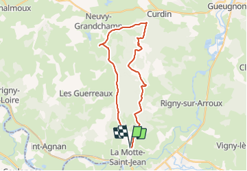
Trail Mountain bike of 27 km to be discovered at Bourgogne-Franche-Comté, Saône-et-Loire, La Motte-Saint-Jean. This trail is proposed by i20.
Positioning
Country:
France
Region :
Bourgogne-Franche-Comté
Department/Province :
Saône-et-Loire
Municipality :
La Motte-Saint-Jean
Location:
Unknown
Start:(Dec)
Start:(UTM)
574164 ; 5150313 (31T) N.
Comments